Land in Surrey, Corner of Pikes Lane & Crowhurst Village Rd, Crowhurst, RH7
- Land size
- 0.06 acres
Key Features
- Stunning Surrey location
- Good transport links into London
- High value area / street
- Freehold
Description
**BEST AND FINAL OFFERS ARE INVITED BY 1PM ON 21/09/2026 - The seller reserves the right to consider suitable proceedable offers prior to the deadline** Rarely available attractive land located in an affluent and picturesque Surrey village. Situated approximately only 6 miles from the M25, offering good access into London.
The site (four separately registered plots) is located in a high-value area of surrey (for example, properties on the same street have sold for over 1.3 million – £1,375,000 on 13/03/2024 and £1,350,000 on 05/10/2010, based on land registry data)
---------------------------------------
PLANNING HISTORY AND DEVELOPMENT POTENTIAL
In 2020 (Ref: APP/M3645/W/19/3233753), the Planning Inspectorate confirmed that proposals for two barn type structures on the site (see image of drawings) would not constitute inappropriate development within the Green Belt, stating, “I have no reason to conclude that the proposal would be inappropriate development within the Green Belt.”
The appeal was dismissed due to the absence of the required ecology survey, which was needed because a new access was initially proposed. Lacking specialist knowledge that such a report would be necessary, the applicant later chose to rely on an existing right of way to avoid unnecessary costs. However, this amendment was submitted too late to be formally considered, though none of these matters affected the suitability of the land or the principle of development.
A later appeal considered a revised application. The Inspector in that case interpreted the proposed buildings as being for equestrian rather than agricultural use. With appropriate professional guidance and clearer supporting information, this matter could have been resolved. Following this, the applicant’s personal circumstances changed, and there was no longer a need to pursue development on the site. The land has remained unused since, presenting a rare opportunity for a new owner to unlock its full potential.
This history clearly demonstrates that appropriately designed agricultural buildings could be supported in the future, particularly with expert planning advice and proactive liaison with the planning authority. The site has previously been used for storage and benefits from a Certificate of Lawful Use (Ref: TA/2016/1239) for grazing and the placement of hedging. The road-facing boundaries already have hedging in place, and further planting could create a more private, well-defined plot. For those wishing to explore residential opportunities, this established lawful use provides a strong foundation under Paragraph 84(e) of the National Planning Policy Framework, offering scope for a thoughtfully designed home in the countryside. Other planning opportunities may also exist, highlighting the site’s versatility and long-term potential.
The planning information provided is for general information and background context only. Interested parties should verify specific details with the local planning authority as required.
---------------------------------------------
Plot A (0.19 acre) - £25,000
Plot B (0.16 acre) - £20,000
Plot C (0.13 acre) - £15000
Plot D (0.06 acre) - £8,995
(Plot D is only available for purchase as part of a combined purchase with one or more of the other plots. It will not be sold separately)
SUBMITTING OFFERS
BEST AND FINAL OFFERS ARE INVITED BY 1PM ON 21/09/2026 - The seller reserves the right to consider suitable proceedable offers prior to the deadline.
Only unconditional offers will be considered (for example, offers subject to finance, planning permission, options will not be accepted).
Please ensure that solicitor details and proof of funds are available prior to making any offer.
If your offer is accepted, solicitor details and proof of funds must be provided immediately. Failure to supply these promptly may result in the seller proceeding with another suitable buyer.
LOCATION & VIEWING:
The site is situated at the corner of Pikes Lane and Crowhurst Village Road in Crowhurst, Lingfield, Surrey. Wooden stakes separate each plot.
The most convenient access is from Crowhurst Village Road, just before the corner with Pikes Lane, where there is a break in the hedge.
To locate the site, copy and paste the following GPS coordinates into Google Maps:
51.200531, -0.011774
The plots are available for unaccompanied viewing. The site may contain overgrowth, falling trees, ditches, uneven surfaces, or other hazards. Visitors are asked to take care and enter at their own risk.
Although viewings are unaccompanied, please book a time slot to avoid overlap with other visitors.
---------------------------------------------------------------------------------------------------
These details are believed to be correct but are not guaranteed and do not form part of any contract.
**ENQUIRIES**
For all enquiries, viewing requests or to create your own listing please visit the Emoov website. If calling, please quote reference: S6058
Map Location
Property details
- Tenure
- Freehold
- Council Tax Band
- Ask Agent
- Date Posted
- 2026-05-23
Utilities & Restrictions
Utilities
- Electricity
- Ask Agent
- Water
- Ask Agent
- Heating
- Ask Agent
- Broadband
- Ask Agent
- Sewerage
- Ask Agent
Rights & Restrictions
- Public Rights of Way
- Ask Agent
- Private Rights of Way
- Ask Agent
- Listed Property
- Ask Agent
- Restrictions
- Ask Agent
Listed status, conservation areas and planning constraints for this location are in the full report.
Property Features
- Accessibility
- Ask Agent
- Parking
- Ask Agent
- Garden
- Ask Agent
Beyond the particulars: planning activity, flood history, heritage and ground risks, checked for this exact spot.
Connectivity
Broadband
Fastest speed available at this postcode
1.8 Gbps
Gigabit full fibre
Suitable for
- 4K streaming on every screen
- Full-time home working
- Online gaming & big downloads
Mobile signal
Outdoor predictions; indoor signal depends on building materials.
Ofcom Connected Nations postcode-level predictions. Speeds and signal are modelled, not measured, and vary between addresses and providers.
Signal is the easy part. Planning activity, flood history and protected designations here are in the full report.
Nearest Schools
Primary
- Lingfield Primary School1.7 milesOfsted report card · Jun 2026
- Ages
- 3 to 11
- Pupils
- 420
- Type
- Community school
- St Stephen's CofE Primary School2 milesOfsted report card · May 2026
- Ages
- 2 to 11
- Pupils
- 248
- Type
- Academy converter
- Faith
- Church of England
- Holland Junior School2.6 milesNo Ofsted rating
- Ages
- 7 to 11
- Pupils
- 167
- Type
- Academy converter
- Dormansland Primary School2.9 milesNo Ofsted rating
- Ages
- 4 to 11
- Pupils
- 207
- Type
- Community school
- St Peter's CofE Infant School3 milesOfsted: Good
- Ages
- 4 to 7
- Pupils
- 85
- Type
- Voluntary aided school
- Faith
- Church of England
Secondary
- Oxted School4.1 milesOfsted report card · Mar 2026
- Ages
- 11 to 18
- Pupils
- 1,528
- Type
- Academy converter
- Imberhorne School4.7 milesNo Ofsted rating
- Ages
- 11 to 18
- Pupils
- 1,558
- Type
- Community school
- Sackville School5.3 milesNo Ofsted rating
- Ages
- 11 to 18
- Pupils
- 1,525
- Type
- Community school
- Oakwood School6.5 milesOfsted report card · Feb 2026
- Ages
- 11 to 16
- Pupils
- 1,610
- Type
- Community school
- Merstham Park School6.9 milesOfsted: Good
- Ages
- 11 to 16
- Pupils
- 711
- Type
- Free schools
Distances are straight-line from the advertised location. Source: the national school registers (DfE, Welsh Government, Scottish Government) and Ofsted.
Schools are just the start: sold prices nearby, planning activity and any flood history are in the full report.
Amenities
Supermarket
GP surgery
Pharmacy
Hospital
Straight-line distances from the advertised location. Sources: NHS records, Geolytix supermarket locations, OS Open Greenspace and the national trails registers.
The area stacks up? Now check the location itself: planning nearby, protected designations and past flooding.
Getting Around
Nearest station
Nearest bus stop
Typical drive times
Straight-line distances from the advertised location; drive times are typical free-flow times over OpenStreetMap road data, so allow more at peak. Public transport locations from DfT NaPTAN.
Easy to reach matters. So do planning activity, flood history and ground risks: all in the full report.
Flood Risk
From Environment Agency flood map open data, checked around the advertised map pin and allowing for the listed acreage where known. This summary comes from LandSale, the advertising platform, not from the listing agent, and is not part of the agent's particulars. Risk can vary across a single holding, so verify anything critical through your own searches before committing.
Rivers and the sea
Surface water
The detail behind these bandings
The full report pinpoints where this location sits on the flood maps, and runs the deeper checks that usually only surface after an offer.
- Exact flood zones & annual chances (included in the full report)
- Any recorded past flooding (included in the full report)
- Planning activity nearby (included in the full report)
- Heritage & conservation (included in the full report)
- Protected nature designations (included in the full report)
- Ground risks (included in the full report)
- Sold prices nearby (included in the full report)
£14.99 · one-off purchase
By LandSale, the platform. Not provided by the listing agent. Ready in about a minute.
Important notice: Information, maps and tags on this page are drawn from the advertising agent's marketing materials or generated automatically. LandSale has not verified them. Relying on these details is at your own risk, always carry out independent checks before committing to a purchase.
LandSale full disclaimer
Marketing information only - not formal particulars. The details on this website are provided for general guidance and do not constitute an offer or contract. Neither LandSale nor the advertising estate/land agent accepts responsibility for any inaccuracy.
1. Source of information
- Listing content: Core description, asking price, tenure, measurements, photographs and planning history originate from the marketing materials of the advertising estate or land agent. LandSale does not author this content and cannot guarantee its accuracy.
- Automated tags & categorisation: Property type, land-use class, acreage bands and similar labels may be applied by machine-learning models. They are intended as a helpful guide only and may not reflect the property's legal status or permitted use.
- Third-party & enriched data layers: Maps, boundary outlines, planning designations, soil reports, broadband coverage and other environmental or location-based insights are licensed from external suppliers. Such data are supplied “as is", may be incomplete or out of date and are subject to change without notice.
2. Verification required
Prospective purchasers must verify critical matters, including but not limited to planning permission, title boundaries, public rights of way, environmental constraints, acreage, services, access and VAT status, through their own inspections, specialist surveys, legal advisers and the selling agent before relying on the information or entering into any contract.
3. No warranty or liability
LandSale gives no warranty, express or implied, as to the accuracy, completeness or fitness for any particular purpose of the information displayed. LandSale shall not be liable for any loss, damage, cost or expense arising directly or indirectly from any use of or reliance on such information, save where liability may not be excluded by law.
4. Updates & feedback
If you believe any detail on this listing is inaccurate, please let us know. We will investigate and, where appropriate, update the listing or notify the agent.
© LandSale | Version 1.3 - August 2026
Listing agent
Emoov, Chelmsford
Marsh House Farm, Lower Burnham Road, Latchingdon Chelmsford, Essex CM3 6HQ
Contact Emoov, Chelmsford
Marsh House Farm, Lower Burnham Road, Latchingdon Chelmsford, Essex CM3 6HQ
View agent profileSimilar properties for sale
- Price
- £8,900
- Size
- 0.26 acres
Crowhurst — Lingfield, Surrey, Crowhurst, Surrey RH7 England
Added on 09/07/2026Vacant Land
- Price
- Guide Price£3,500
- Size
- 0.25 acres
Land at Down Lane, Compton, Surrey, Compton, Surrey GU3 England
Added on 17/07/2026Amenity Land
- Price
- Offers in Region of£15,000
Huntercombe Lane South, Slough, Berkshire, SL6, Burnham, Buckinghamshire SL6 England
Added on 16/06/2026Farmland
- Price
- £13,900
- Size
- 0.34 acres
Flaunden - Hertfordshire, Flaunden, Hertfordshire HP3 England
Added on 30/06/2026Vacant Land Added on 29/01/2026Farmland
- Price
- £7,300
- Size
- 0.21 acres
Added on 09/07/2026Vacant Land
- Price
- Fixed Price£8,200
- Size
- 0.1 acres
Wallingford - Oxfordshire, Cholsey, Oxfordshire OX10 England
Added on 30/06/2026Small Plot of Land
- Price
- £9,000
- Size
- 0.18 acres
LAND Plots 48 Brackley Road MK18, Buckingham, Buckinghamshire MK18 England
Added on 29/01/2026Vacant Land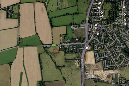
- Price
- Guide Price£7,000
Great North Road, Buckden, St. Neots, Wyboston, Chawston and Colesden, Bedford MK44 England
Added on 09/07/2026Vacant Land
- Price
- Offers in Excess of£20,000
- Size
- 0.35 acres
Brackley Road, Buckingham MK18, Buckingham, Buckinghamshire MK18 England
Added on 29/01/2026Vacant Land