Land , Charlton Road, Shepton Mallet, BA4 5PE
- Land size
- 0.7 acres
Key Features
- Town Centre Position
- PP granted 2023 for a Nursery/Pre-School
- 0.7 Acres
- Located in Conservation Area
Description
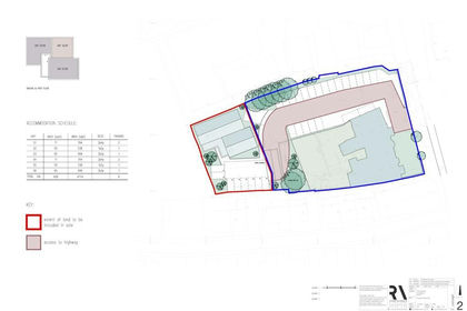
A town centre site, extending to 0.7 acre (0.3ha), with consent for change of use from agricultural to use Class E (f) and erection of a Nursery and Pre-School building and associated access and parking. The decision was granted September 2023 subject to conditions, reference 2023/0338/FUL. It boasts potential for E (f) class development or may attract interest for those seeking an amenity parcel or alternative development, subject to necessary consents.
A town centre site, extending to 0.7 acre (0.3ha), with consent for change of use from agricultural to use Class E (f) and erection of a Nursery and Pre-School building and associated access and parking. The decision was granted September 2023 subject to conditions, reference 2023/0338/FUL. It boasts potential for E (f) class development or may attract interest for those seeking an amenity parcel or alternative development, subject to necessary consents.
Situated close to Shepton Mallet town centre immediately adjacent Whitstone Secondary School and nearby the former Shepton Mallet Prison a heritage led immersive tourist attraction. It is located in a conservation area.
The site is rectangular and slopes in elevation down from the road. There is good roadside frontage onto Charlton Road extending to approximately 100ft (30m) currently enclosed by a stone wall.
A new access will need to be created leading from Charlton Road and the proposed development was subject to a pre-commencement condition in relation to the access, parking and turning areas. There were also conditions in relation to conservation, drainage, wildlife and badger protection, lighting and tree protection plan.
We are not aware of services being connected. Interested parties must rely upon their own investigations and satisfy themselves regarding location and capacity of nearby utilities connections.
The land can be seen from the public pavement along Charlton Road and for walk over onsite inspections please make prior appointment through the sole agents Cooper and Tanner 1908 Limited -
No VAT payable
For full planning information please visit Somerset planning portal (former Mendip area) application number 2023/0338/FUL. Within Conservation Area (DP3) and identified within DP2 open space of local significance.
Freehold
Town Centre Position
PP granted 2023 for a Nursery/Pre-School
0.7 Acres
Located in Conservation Area
Map Location
Property details
- Tenure
- Freehold
- Council Tax Band
- Ask Agent
- Date Posted
- 2026-05-14
Utilities & Restrictions
Utilities
- Electricity
- Ask Agent
- Water
- Ask Agent
- Heating
- Ask Agent
- Broadband
- Ask Agent
- Sewerage
- Ask Agent
Rights & Restrictions
- Public Rights of Way
- Ask Agent
- Private Rights of Way
- Ask Agent
- Listed Property
- Ask Agent
- Restrictions
- Ask Agent
Property Features
- Accessibility
- Ask Agent
- Parking
- Parking Available
- Garden
- Ask Agent
Important notice: Information, maps and tags on this page are supplied by the advertising agent or generated automatically. LandSale has not verified them. Relying on these details is at your own risk, always carry out independent checks before committing to a purchase.
LandSale full disclaimer
Marketing information only - not formal particulars. The details on this website are provided for general guidance and do not constitute an offer or contract. Neither LandSale nor the advertising estate/land agent accepts responsibility for any inaccuracy.
1. Source of information
- Agent-supplied content: Core description, asking price, tenure, measurements, photographs and planning history are uploaded by the appointed agent, who remains solely responsible for their accuracy.
- Automated tags & categorisation: Property type, land-use class, acreage bands and similar labels may be applied by machine-learning models. They are intended as a helpful guide only and may not reflect the property's legal status or permitted use.
- Third-party & enriched data layers: Maps, boundary outlines, planning designations, soil reports, broadband coverage and other environmental or location-based insights are licensed from external suppliers. Such data are supplied “as is", may be incomplete or out of date and are subject to change without notice.
2. Verification required
Prospective purchasers must verify critical matters, including but not limited to planning permission, title boundaries, public rights of way, environmental constraints, acreage, services, access and VAT status, through their own inspections, specialist surveys, legal advisers and the selling agent before relying on the information or entering into any contract.
3. No warranty or liability
LandSale gives no warranty, express or implied, as to the accuracy, completeness or fitness for any particular purpose of the information displayed. LandSale shall not be liable for any loss, damage, cost or expense arising directly or indirectly from any use of or reliance on such information, save where liability may not be excluded by law.
4. Updates & feedback
If you believe any detail on this listing is inaccurate, please let us know. We will investigate and, where appropriate, update the listing or notify the agent.
© LandSale | Version 1.2 - January 2026
Listing agent
Cooper and Tanner, Cooper and Tanner Commercial
41 High Street, Glastonbury, BA6 9DS
Contact Cooper and Tanner, Cooper and Tanner Commercial
41 High Street, Glastonbury, BA6 9DS
View agent profileSimilar properties for sale
- Price
- Offers in Excess of£180,000
- Size
- 0.15 acres
Added on 28/01/2026Development Land
- Price
- Offers in Region of£175,000
- Size
- 0.03 acres
Added on 15/04/2026Industrial Land
- Price
- £130,000
High Street, Westbury On Trym, Bristol, BS9, Bristol North West, Bristol, City of BS9 3ED England
Added on 16/04/2026Commercial Land
- Price
- Guide Price£135,000
- Size
- 0.02 acres
Unit O16, Westpark, Chelston, Wellington, Somerset, TA21 9SF, Wellington, Somerset TA21 9SF England
Added on 25/06/2026WarehouseLeasehold
- Price
- Guide Price£135,000
Westpark, Chelston, Wellington, Somerset, TA21, Wellington, Somerset TA21 9SF England
Added on 25/06/2026Industrial Land
- Price
- Guide Price£135,000
Westpark, Chelston, Wellington, Somerset, TA21, Wellington, Somerset TA21 9SF England
Added on 25/06/2026Industrial Land
- Price
- Guide Price£135,000
- Size
- 0.02 acres
Unit O17, Westpark, Chelston, Wellington, Somerset, TA21 9SF, Wellington, Somerset TA21 9SF England
Added on 25/06/2026WarehouseLeasehold
- Price
- £130,000
- Size
- 0.03 acres
Added on 25/06/2026Industrial Land
- Price
- £130,000
- Size
- 0.03 acres
Added on 02/07/2026Industrial Land
- Price
- Guide Price£175,000
- Size
- 0.17 acres
Added on 02/07/2026Industrial Land