Lairds Loch, Coupar Angus, Blairgowrie, PH13 9LA
- Land size
- 59.25 acres
Key Features
- UNDER OFFER
- Rare opportunity to acquire an exceptionally beautiful land parcel
- Excellent opportunities for habitat management and woodland management
- Total area extends to 59.25 Acres (23.98 Ha)
Description
The subjects of sale form an amenity woodland and Loch, both accessible by foot with car parking at the entrance. There are signs that historically vehicular access may have been possible but this is now largely overgrown. This is clearly a much-enjoyed area of land, formerly known as the Hallyburton Estate Community Woodland, we understand Woodland Grant Schemes were carried out between 1991 and 2002 across the land and its peripheries. There are some beautiful viewpoints, picnic areas, woodland and Lochside walks and immediate access to the adjacent woodland walk at North Ballo Hill. The lochs have been occupied in recent years by commercial tenants, offering fishing for coarse fish then more recently for stocked trout. Its variable depth, weed cover, and lack of algae make it a very suitable habitat for fishing. The loch is registered under the Reservoirs Act and holds a SSSI designation. Laird’s Loch was notified as a Site of Special Scientific Interest on the basis of its open water, aquatic plant communities and extensive fringing acidic mires. Laird’s Loch is naturally mesotrophic and lies in a shallow, flat basin. It is evidenced from reports that the bottom of the loch is mud and silt, lying over gravel and stones and that the loch is largely between 1 and 2 metres deep but is dammed and deeper at its western end. We understand that it is drained by a small stream. The loch is notable for the number of pondweed species. The acidic mires fringing the loch are the most extensive of their type in the Sidlaw Hills. The path linking the woodland to the path network around North Ballo Hill to the southwest of Laird’s Loch runs along the north side of the loch within a few feet of the shoreline.
There is a structure by the Lochside, which we assume to have been a boathouse which is now in very poor repair. There are no services available.
The sellers have declared that the amenity woodland is of a mixed age comprising of mainly native conifers and broadleaves.
Location
This idyllic land parcel is located approximately 4.2 miles south east of Coupar Angus. Coupar Angus is a popular town within commuting distance of the larger centres of Dundee and Perth. The town is well places for access to A90 some 15 miles to the east which links Dundee and Aberdeen. There is an established parking bay at the entrance to the woodland where a number of paths have been established around North Ballo Hill and Lairds Loch.
ENVIRONMENTAL DESIGNATIONS
We understand that the area is approved for Species Conservation under FGS. It is about reducing deer impact to allow regeneration, controlling grey squirrels to help the red population and controlling pests for Capercaillie and Black Grouse.
The area has FGS Eligibility as a Grey Squirrel Control area. The aim of this option is to support the targeted control of grey squirrels in areas where they are a threat to red squirrel populations. This support is offered via the Forestry Grant Scheme - SMF - Species Conservation - Grey Squirrel Control
In addition the area is recognised as FGS Eligibility Native Woodland Habitat Network and approved for fencelines and native woodland surveys.
There is a prehistoric Scheduled Ancient Monument (Hill Fort) within proximity to the subjects of sale, previously cleared of trees to the north of the Loch. Reference: Hill of Dores, SM7315.
THIRD PARTY RIGHTS AND SERVITUDES
The land is affected by overhead lines for which we assume servitudes are in place. The car park will be included within the sale with unrestricted access rights over retained by the seller, to allow access to their lands to the North West (the car park is hatched in red on the attached sales plan). The land to the south is owned by Forest and land Scotland who hold servitude rights of access over the subjects of sale. The subjects are sold together with and subject to all existing rights of way, servitudes, wayleaves and others whether contained in the Title Deeds or otherwise, and purchasers will be deemed as satisfied themselves in respect thereof.
Map Location
Property details
- Tenure
- Freehold
- Council Tax Band
- Ask Agent
- Date Posted
- 2026-05-01
Market Value Analysis
Compared with 10 Woodland listings in Scotland (50+ acres).
Utilities & Restrictions
Utilities
- Electricity
- Ask Agent
- Water
- Ask Agent
- Heating
- Ask Agent
- Broadband
- Ask Agent
- Sewerage
- Ask Agent
Rights & Restrictions
- Public Rights of Way
- Ask Agent
- Private Rights of Way
- Ask Agent
- Listed Property
- Ask Agent
- Restrictions
- Ask Agent
Property Features
- Accessibility
- Ask Agent
- Parking
- Parking Available
- Garden
- Ask Agent
Important notice: Information, maps and tags on this page are supplied by the advertising agent or generated automatically. LandSale has not verified them. Relying on these details is at your own risk, always carry out independent checks before committing to a purchase.
LandSale full disclaimer
Marketing information only - not formal particulars. The details on this website are provided for general guidance and do not constitute an offer or contract. Neither LandSale nor the advertising estate/land agent accepts responsibility for any inaccuracy.
1. Source of information
- Agent-supplied content: Core description, asking price, tenure, measurements, photographs and planning history are uploaded by the appointed agent, who remains solely responsible for their accuracy.
- Automated tags & categorisation: Property type, land-use class, acreage bands and similar labels may be applied by machine-learning models. They are intended as a helpful guide only and may not reflect the property's legal status or permitted use.
- Third-party & enriched data layers: Maps, boundary outlines, planning designations, soil reports, broadband coverage and other environmental or location-based insights are licensed from external suppliers. Such data are supplied “as is", may be incomplete or out of date and are subject to change without notice.
2. Verification required
Prospective purchasers must verify critical matters, including but not limited to planning permission, title boundaries, public rights of way, environmental constraints, acreage, services, access and VAT status, through their own inspections, specialist surveys, legal advisers and the selling agent before relying on the information or entering into any contract.
3. No warranty or liability
LandSale gives no warranty, express or implied, as to the accuracy, completeness or fitness for any particular purpose of the information displayed. LandSale shall not be liable for any loss, damage, cost or expense arising directly or indirectly from any use of or reliance on such information, save where liability may not be excluded by law.
4. Updates & feedback
If you believe any detail on this listing is inaccurate, please let us know. We will investigate and, where appropriate, update the listing or notify the agent.
© LandSale | Version 1.2 - January 2026
Listing agent
DM Hall, Bridge of Allan
Station Road, Bridge Of Allan, Stirling, FK9 4JS
View agent profileSimilar properties for sale

- Price
- Offers Over£120,000
Auchterhouse, Dundee, Angus and Perthshire Glens, Angus DD3 0QS Scotland
Added on 24/03/2026Development Land
- Price
- Offers in Excess of£150,000
Added on 29/01/2026Redevelopment Land
- Price
- Offers Over£110,000
- Size
- 29.21 acres
Added on 28/01/2026Farmland
- Price
- Offers Over£200,000
- Size
- 59.92 acres
Added on 28/01/2026Farmland
- Price
- Offers Over£125,000
The Aberdeenshire Portfolio, Aberdeenshire, Aberdeen South, Aberdeen City AB14 0AE Scotland
Added on 29/01/2026Woodland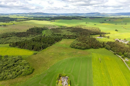
- Price
- Offers Over£110,000
- Size
- 56 acres
Added on 24/06/2026Woodland
- Price
- Offers Over£149,995
Lanark Road, Crossford, Carluke, Hamilton and Clyde Valley, South Lanarkshire ML8 5RE Scotland
Added on 10/04/2026Redevelopment Land
- Price
- Offers Over£110,000
- Size
- 0.41 acres
Plot 2, Castletown, Daviot, Inverness, Skye and West Ross-shire, Highland IV2 5EP Scotland
Added on 26/03/2026Building Plot
- Price
- Offers in Excess of£125,000
- Size
- 7.85 acres
Kelso, Roxburghshire, TD5, Berwickshire, Roxburgh and Selkirk, Scottish Borders TD5 8EQ Scotland
Added on 06/05/2026Equestrian property
- Price
- Offers Over£110,000
- Size
- 0.41 acres
Plot 1, Castletown, Daviot, Moray West, Nairn and Strathspey, Moray IV36 3EE Scotland
Added on 26/03/2026Building Plot