POTENTIAL DEVELOPMENT OPPORTUNITY, Paignton, Devon, TQ3
- Land size
- 0.68 acres
Key Features
- Conditional offers invited (Subject to planning)
- Land extending to c. 0.68 acres
- Proposed for allocation in the Torbay Local Plan 2022 - 2040
- Confirmed in recent HELAA as being suitable for up to 10 dwellings
Description
THE LAND - TQ3 3GF
Comprising of land held under title DN385278, this potential development opportunity extends to c. 0.28 ha / 0.68 acres and is situated on the northwestern edge of Paignton. The land was proposed for allocation and the future development of c. 10 dwellings within the Torbay Local Plan 2022-40: Regulation 18 Site Options Consultation Document (October 2022) under reference H2P05. It was also shown as being suitable for development within the within the 2021 HELAA under reference 21P081.
The land is currently vacant and laid to grass sloping gently from west to east - it is surrounded by existing residential housing on 3 sides (Heligan Close and Fishacre Close). To the north the land borders a small lane (Luscombe Lane) beyond which is agricultural land - this proposed as being allocated for future residential housing development and planning permission for a discount
supermarket was granted in May 2022.
PAIGNTON
Paignton is a seaside town on the coast; together with Torquay and Brixham it forms the borough of Torbay which was created in 1998. The area forms part of the holiday destination known as the English Riviera.
Comprehensive facilities for shopping, leisure, education and health are readily available within the Borough of Torbay. It has National Rail links from its railway stations at Torquay and Paignton and has swift connections via the A380 to the National Motorway network (M5) on the outskirts of the cathedral city of Exeter. Exeter Airport also offers a range of scheduled and charter flights to destinations throughout the UK and Europe with connections to international flights.
METHOD OF SALE
The freehold land is offered for sale by private treaty with offers invited on a conditional, subject to planning basis. Unconditional offers may also be considered.
PLANNING
Historically, the land was proposed for development as part of a wider scheme for 62 dwellings, under application reference P/1990/1116 (Erection Of 62 Dwellings, Estate Road/Footpaths, Storm Water Lagoon and Sewers, (As Revised By Plans Received 4th June 1991 And 21st June 1991) - Land West Of Kings Ash Road Opp. Fernicombe/Smallcombe Rds Paignton). There are no recent planning applications or approvals relating to the land to the agents knowledge.
UTILITIES
Given the surrounding residential properties, the agents understand that all mains services are available close by for connection. Interested parties should however make and rely upon their own enquiries as to the availability and capacity of required utility services prior to making any offer.
VIEWING
Strictly by appointment only - please contact KLP to arrange to view the site.
Map Location
Property details
- Tenure
- Ask Agent
- Council Tax Band
- Ask Agent
- Date Posted
- 2026-04-28
Utilities & Restrictions
Utilities
- Electricity
- Ask Agent
- Water
- Ask Agent
- Heating
- Ask Agent
- Broadband
- Ask Agent
- Sewerage
- Ask Agent
Rights & Restrictions
- Public Rights of Way
- Ask Agent
- Private Rights of Way
- Ask Agent
- Listed Property
- Ask Agent
- Restrictions
- Ask Agent
Property Features
- Accessibility
- Ask Agent
- Parking
- Ask Agent
- Garden
- Ask Agent
Important notice: Information, maps and tags on this page are supplied by the advertising agent or generated automatically. LandSale has not verified them. Relying on these details is at your own risk, always carry out independent checks before committing to a purchase.
LandSale full disclaimer
Marketing information only - not formal particulars. The details on this website are provided for general guidance and do not constitute an offer or contract. Neither LandSale nor the advertising estate/land agent accepts responsibility for any inaccuracy.
1. Source of information
- Agent-supplied content: Core description, asking price, tenure, measurements, photographs and planning history are uploaded by the appointed agent, who remains solely responsible for their accuracy.
- Automated tags & categorisation: Property type, land-use class, acreage bands and similar labels may be applied by machine-learning models. They are intended as a helpful guide only and may not reflect the property's legal status or permitted use.
- Third-party & enriched data layers: Maps, boundary outlines, planning designations, soil reports, broadband coverage and other environmental or location-based insights are licensed from external suppliers. Such data are supplied “as is", may be incomplete or out of date and are subject to change without notice.
2. Verification required
Prospective purchasers must verify critical matters, including but not limited to planning permission, title boundaries, public rights of way, environmental constraints, acreage, services, access and VAT status, through their own inspections, specialist surveys, legal advisers and the selling agent before relying on the information or entering into any contract.
3. No warranty or liability
LandSale gives no warranty, express or implied, as to the accuracy, completeness or fitness for any particular purpose of the information displayed. LandSale shall not be liable for any loss, damage, cost or expense arising directly or indirectly from any use of or reliance on such information, save where liability may not be excluded by law.
4. Updates & feedback
If you believe any detail on this listing is inaccurate, please let us know. We will investigate and, where appropriate, update the listing or notify the agent.
© LandSale | Version 1.2 - January 2026
Listing agent
KLP, Exeter
Newcourt Barton Clyst Road, Topsham, EX3 0DB
Similar properties for sale

- Price
- Guide Price£650,000
- Size
- 3 acres
Added on 29/01/2026Development Land Added on 18/06/2026Development Land
- Price
- POA
- Size
- 2.92 acres
Added on 29/01/2026Development Land Added on 29/01/2026Building Plot
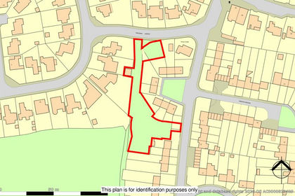
- Price
- Guide Price£150,000
- Size
- 0.53 acres
Added on 11/07/2026Development Land
- Price
- Guide Price£200,000
Old Milling Barn, Longcombe, Totnes, Berry Pomeroy, Devon TQ9 6PW England
Added on 26/03/2026Building Plot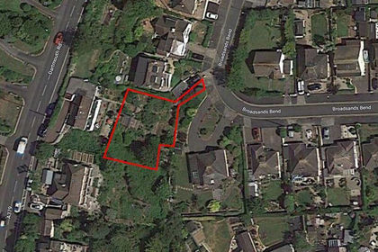
- Price
- Offers in Excess of£200,000
Dartmouth Road, Paignton, South Devon, Torbay TQ4 6JH England
Added on 05/06/2026Building Plot
- Price
- Offers in Excess of£1,000,000
Added on 22/05/2026Development Land
- Price
- £1,000,000
- Size
- 0.5 acres
Croft Road, Torquay, Devon, TQ2, Torbay, Torbay TQ2 5UD England
Added on 17/07/2026Development Land
- Price
- Guide Price£20,000
- Size
- 0.17 acres
Auction Lot: Development Land with lapsed planning, Torquay, Devon, Torbay, Torbay TQ2 5SP England
Added on 11/05/2026Development Land