Hardwick, Norfolk
- Land size
- 6.6 acres
- Bedrooms
- 6
- Bathrooms
- 3
Key Features
- Wonderful 6 bedroom Grade II listed character home, with parts dating back to 16th century
- Set in around 6.6 acres of mature garden, grounds and plantation
- Accommodation across three floors in main house
- Self contained 2 bedroom annex, with permission for use as holiday let
- Large barn, open cart lodge and various clay lump outbuilding
- Abundance of stand out features throughout
- Non-estate, village location
- Around 14 miles from Norwich
Description
Grade II listed 6 bedroom residence set in around 6.6 acres of mature grounds and established plantation. Self contained 2 bedroom annex with separate driveway. Large barn with range of outbuildings. Abundance of character.
Location
Hardwick is a small, quiet village nestled just a few miles to the east of Long Stratton, a well served town which plays host to a good selection of local shops, businesses and daily amenities, including a Co-op supermarket and fuel stations/garage. Hardwick is just a couple of miles from the A140, a route which runs north towards the historic and cultural city of Norwich (15 miles) and south, towards Diss (13 miles).
The Property
Attractive Grade II listed 6 bedroom family residence with parts of the building dating back to 16th century, with later additions/extensions in more recent times. The house carefully underwent extensive refurbishment a couple of decades ago under the stewardship of the current owners, with the sellers placing huge emphasis on retaining the charm and abundance of original character the property possesses. There are great social spaces to enjoy, such as the 'country style' fitted kitchen/diner, juxtaposing a cosy snug and formal reception room with prominent features, the living/dining room with exposed timbers and imposing inglenook fireplace which neighbours a ‘sub level’ Library/study, with inset timbers and remnant Mullion windows; both rooms are shining examples of where the heritage of this wonderful property is distinctly on show. As can be seen from the floor plan, the bedrooms are spread across two upper floors, from ‘halfway’ landings, via an intriguing curving stairwell. The main bedroom suite is generous in size, with dressing room leading to an en-suite bathroom, boasting a roll top bath. A spacious ‘split level’ guest bedroom suite is discretely found from a separate staircase accessed from the kitchen/diner.
Garden & grounds
A main driveway leads off the highway, passing an established willow and opening to the parking area, adjacent to two similar sized brick Nissan huts/garaging. Picket fencing opens onto the private, mature lawns which sweep around the main house to where a patio area can be found. Beyond the formal gardens are a gate and a large open ended storage outbuilding, both giving access onto a section of wild garden which edges the plantation. The established plantation covers over 4 acres of the entire grounds and comprises an area of uniformly planted pine trees, tall Leylandii and more - which is an absolute haven for wildlife. A natural pathway works its way around the edge and provides a unique and tranquil place to walk and enjoy nature on your very doorstep!
The barn and cart-lodge
A large, 30’ timber clad barn is an ideal storage facility and sides onto the adjoining open ended, cart-lodge with storage attic above.
The annexe, office and other outbuildings.
Gates open to a secondary driveway offering plenty of space for vehicles to park. A secure double garage joins to a useful home office, providing a great place to work. Three further clay lump stores are handy for additional storage needs. The annex sits independently from the main house and has successfully been used as a holiday let for several years, however, could equally provide a perfect solution for older or younger family members, independent or multi-generational living. The main annex living room is light and holds a ‘wow’ factor due to its vaulted height and open staircase leading to the twin bedroom. A functional well fitted kitchen/diner holds charming features of its own. A ground floor main bedroom and bathroom complete the accommodation.
Agent note:
Council Tax band was issued prior to annex accommodation.
Services:
Both house and annex have independent oil fired central heating systems. Both have mains water and electricity. Separate private drainage systems.
Viewing:
By appointment via TW Gaze.
How to get there:
What3words:///perch.subjects.artist
Tenure: Freehold
Council Tax: D
Anti-Money Laundering, Terrorist Financing and Transfer of funds Regulations 2017.
In line with the regulations, TW Gaze are legally required to carry out AML due diligence checks on all proposed legal purchasers involved in the transaction. A charge of £25.00 + VAT (£30.00 Inc VAT) processing fee is applicable for each purchaser once an acceptable offer is agreed.
Ref: 2/19876/RM
Map Location
Property details
- Tenure
- Freehold
- Council Tax Band
- D
- Date Posted
- 2026-04-24
Market Value Analysis
Compared with 213 Homes with Land listings in East Anglia (5+ acres).
Utilities & Restrictions
Utilities
- Electricity
- Mains
- Water
- Mains
- Heating
- Oil Heating
- Broadband
- Ask Agent
- Sewerage
- Septic Tank / Private
Rights & Restrictions
- Public Rights of Way
- Ask Agent
- Private Rights of Way
- Ask Agent
- Listed Property
- Ask Agent
- Restrictions
- Yes
Listed status, conservation areas and planning constraints for this location are in the full report.
Property Features
- Accessibility
- Ask Agent
- Parking
- Garage, Covered Parking, Driveway
- Garden
- Garden
Beyond the particulars: planning activity, flood history, heritage and ground risks, checked for this exact spot.
Connectivity
Broadband
Fastest speed available at this postcode
80 Mbps
Superfast
Suitable for
- HD streaming
- Video calls
- Web & social
Mobile signal
Outdoor predictions; indoor signal depends on building materials.
Ofcom Connected Nations postcode-level predictions. Speeds and signal are modelled, not measured, and vary between addresses and providers.
Signal is the easy part. Planning activity, flood history and protected designations here are in the full report.
Nearest Schools
Primary
- Manor Field Infant and Nursery School2.5 milesNo Ofsted rating
- Ages
- 3 to 7
- Pupils
- 111
- Type
- Academy converter
- Pulham Church of England Primary Academy2.7 milesOfsted: Requires improvement *
- Ages
- 4 to 11
- Pupils
- 98
- Type
- Academy converter
- Faith
- Church of England
- St Mary's Church of England Junior Academy2.7 milesOfsted: Good *
- Ages
- 7 to 11
- Pupils
- 148
- Type
- Academy converter
- Faith
- Church of England
- Hempnall Primary School3.2 milesOfsted: Good
- Ages
- 5 to 11
- Pupils
- 155
- Type
- Community school
- Alburgh With Denton Church of England Primary Academy3.6 milesNo Ofsted rating
- Ages
- 4 to 11
- Pupils
- 99
- Type
- Academy converter
- Faith
- Church of England
Secondary
- Long Stratton High School2.6 milesOfsted report card · Feb 2026
- Ages
- 11 to 16
- Pupils
- 679
- Type
- Academy sponsor led
- The Harleston Sancroft Academy (a 3-16 Church of England School)4.4 milesOfsted: Good *
- Ages
- 3 to 16
- Pupils
- 824
- Type
- Academy converter
- Faith
- Church of England
- Bungay High School7.5 milesOfsted report card · Mar 2026
- Ages
- 11 to 18
- Pupils
- 922
- Type
- Academy converter
- Diss High School8.5 milesNo Ofsted rating
- Ages
- 11 to 18
- Pupils
- 877
- Type
- Academy converter
- Framingham Earl High School8.9 milesNo Ofsted rating
- Ages
- 11 to 16
- Pupils
- 791
- Type
- Academy converter
* Latest graded judgement covers quality of education only; no overall grade was issued under the 2024-25 inspection framework.
Distances are straight-line from the advertised location. Source: the national school registers (DfE, Welsh Government, Scottish Government) and Ofsted.
Schools are just the start: sold prices nearby, planning activity and any flood history are in the full report.
Amenities
Supermarket
GP surgery
Pharmacy
Hospital
Straight-line distances from the advertised location. Sources: NHS records, Geolytix supermarket locations, OS Open Greenspace and the national trails registers.
The area stacks up? Now check the location itself: planning nearby, protected designations and past flooding.
Getting Around
Nearest station
Nearest bus stop
Typical drive times
Straight-line distances from the advertised location; drive times are typical free-flow times over OpenStreetMap road data, so allow more at peak. Public transport locations from DfT NaPTAN.
Easy to reach matters. So do planning activity, flood history and ground risks: all in the full report.
Flood Risk
From Environment Agency flood map open data, checked around the advertised map pin and allowing for the listed acreage where known. This summary comes from LandSale, the advertising platform, not from the listing agent, and is not part of the agent's particulars. Risk can vary across a single holding, so verify anything critical through your own searches before committing.
Rivers and the sea
Surface water
The detail behind these bandings
The full report pinpoints where this location sits on the flood maps, and runs the deeper checks that usually only surface after an offer.
- Exact flood zones & annual chances (included in the full report)
- Any recorded past flooding (included in the full report)
- Planning activity nearby (included in the full report)
- Heritage & conservation (included in the full report)
- Protected nature designations (included in the full report)
- Ground risks (included in the full report)
- Sold prices nearby (included in the full report)
£14.99 · one-off purchase
By LandSale, the platform. Not provided by the listing agent. Ready in about a minute.
Important notice: Information, maps and tags on this page are drawn from the advertising agent's marketing materials or generated automatically. LandSale has not verified them. Relying on these details is at your own risk, always carry out independent checks before committing to a purchase.
LandSale full disclaimer
Marketing information only - not formal particulars. The details on this website are provided for general guidance and do not constitute an offer or contract. Neither LandSale nor the advertising estate/land agent accepts responsibility for any inaccuracy.
1. Source of information
- Listing content: Core description, asking price, tenure, measurements, photographs and planning history originate from the marketing materials of the advertising estate or land agent. LandSale does not author this content and cannot guarantee its accuracy.
- Automated tags & categorisation: Property type, land-use class, acreage bands and similar labels may be applied by machine-learning models. They are intended as a helpful guide only and may not reflect the property's legal status or permitted use.
- Third-party & enriched data layers: Maps, boundary outlines, planning designations, soil reports, broadband coverage and other environmental or location-based insights are licensed from external suppliers. Such data are supplied “as is", may be incomplete or out of date and are subject to change without notice.
2. Verification required
Prospective purchasers must verify critical matters, including but not limited to planning permission, title boundaries, public rights of way, environmental constraints, acreage, services, access and VAT status, through their own inspections, specialist surveys, legal advisers and the selling agent before relying on the information or entering into any contract.
3. No warranty or liability
LandSale gives no warranty, express or implied, as to the accuracy, completeness or fitness for any particular purpose of the information displayed. LandSale shall not be liable for any loss, damage, cost or expense arising directly or indirectly from any use of or reliance on such information, save where liability may not be excluded by law.
4. Updates & feedback
If you believe any detail on this listing is inaccurate, please let us know. We will investigate and, where appropriate, update the listing or notify the agent.
© LandSale | Version 1.3 - August 2026
Listing agent
TW Gaze, Diss
10 Market Hill, Diss, IP22 4WJ
Similar properties for sale
- Price
- Offers in Excess of£850,000
- Size
- 4 acres
The Street, Tharston, Tharston and Hapton, Norfolk NR15 England
Added on 24/05/2026Farmhouse
- Price
- Guide Price£1,150,000
- Size
- 6.1 acres
Added on 14/06/2026Farmhouse
- Price
- Guide Price£1,100,000
- Size
- 6.3 acres
Added on 11/06/2026Farmhouse
- Price
- Guide Price£1,250,000
- Size
- 6.1 acres
Littlebeck Lane, Brooke, Norfolk, NR15, Brooke, Norfolk NR15 England
Added on 30/07/2026House with Land
- Price
- £1,300,000
- Size
- 5 acres
Rode Lane, Carleton Rode, Carleton Rode, Norfolk NR16 England
Added on 29/01/2026House with Land
- Price
- Guide Price£900,000
- Size
- 3.5 acres
Added on 15/07/2026House with Land
- Price
- Guide Price£1,300,000
- Size
- 5 acres
Added on 28/01/2026Barn Conversion
- Price
- Guide Price£1,100,000
- Size
- 3 acres
Added on 25/03/2026House with Land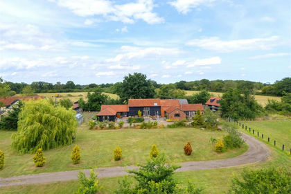
- Price
- Guide Price£850,000
- Size
- 12 acres
Wissett Road, Chediston, Halesworth, Chediston, Suffolk IP19 England
Added on 29/01/2026House with Land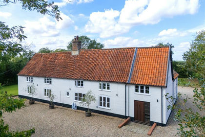
- Price
- £1,250,000
- Size
- 4.5 acres
Added on 05/03/2026Farmhouse