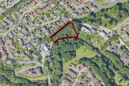
Gillingshill Reservoir & Nature Reserve, Arncroach, Anstruther, Fife, KY10
- Land size
- 17.89 acres
Key Features
- 7.24 ha (17.89 acres)
- Well maintained footpaths
- Diverse habitats and wildlife
- Upper reservoir
- Central woodland area
- Lower gorse scrubland
- Dreel Burn running through
- On site car park
- NO residential or holiday pods
Description
Unexpectedly back to the market - A much loved nature reserve including a reservoir, extending to 7.24 hectares (17.89 acres). With diverse habitats and wildlife and a network of well-maintained footpaths.
Gillingshill Reservoir has progressed from a vital Victorian-era water supply into a much loved local nature reserve. Once serving the surrounding communities until the early 2000s, the site was officially designated a Local Nature Reserve in 2005 and opened to the public the following year.
Managed by Fife Council, the reserve is a valued conservation area that supports a rich diversity of habitats and species. The landscape is naturally divided into three distinct zones. The upper section is dominated by the reservoir itself. The central area features a peaceful stretch of woodland, and the lower section is made up of regenerating scrub, young trees, and grassland.
Flowing through the heart of the reserve, the Dreel Burn connects these zones, enhancing the ecological richness of the site. Over recent years, significant improvements have been made to access the various parts of the reserve, including maintaining high water levels in the reservoir to attract waterfowl and other aquatic species.
The lower section is particularly striking in spring and summer, with extensive gorse scrub providing vibrant colour and shelter for a wide variety of resident and migratory birds. Along the banks of the Dreel Burn, willow adds to the natural charm and biodiversity.
Visitors can explore the reserve by means of a network of well-maintained footpaths that begin at the on-site car park. These trails offer access to the area’s diverse habitats and wildlife, including the local swans, and lead to points of interest such as the reservoir overflow, where water cascades over a series of concrete steps.
PLEASE NOTE: No residential development or holiday pods will be allowed on the Nature Reserve.
Net Area
The combined area of the reservoir and reserve extends to approximately 7.24 hectares (17.89 acres).
Management Agreement
The successful purchasers of Gillingshill will be required to enter into a Management Agreement to ensure the ongoing preservation of the area, safeguarding its rich biodiversity and supporting the wide variety of wildlife that inhabits it while also maintaining its value as a place of enjoyment for both local residents and visitors.
Reservoirs Act
Interested parties must note that the reservoir is regulated by the Reservoirs (Scotland) Act 2011 and the successful purchaser will be responsible for adhering to the legislation and applying to SEPA to become the registered Reservoir Manager. This legislation provides that the reservoir musts be regularly inspected for health and safety purposes. The latest Section 47 and Section 50 Reports form part of the sales pack. The reservoir’s major inspections are on a 10 year cycle and the next 10 year inspection under Section 47 is due not later than 13 November 2028.
The Reservoir and Nature Reserve is located in the scenic East Neuk of Fife just north of Anstruther. The town is the largest community on the Firth of Forth's north-shore coastline. Founded as a fishing village, Anstruther is home to the Scottish Fisheries Museum. Sightseeing wildlife cruises operate from the harbour to the Isle of May, the UK's primary puffin location. An abundance of other wildlife, including seal colonies, also inhabit the island. The town has a small golf course and is also close to the Caves of Caiplie situated on the coastal path to Crail.
Close by, St Andrews has a wide variety of shops, hotels, restaurants, and recreational and cultural facilities. To the south, the East Neuk of Fife stretches along a spectacular coastline with fishing villages built around picturesque harbours and sandy unspoilt beaches. To the north, the Tay Road Bridge provides easy access to Dundee, Angus and Aberdeen.
Travel north west on the main road out of the village of Arncroach and after about 600 m, the car park entrance to the Nature Reserve is on the left.
For viewers using the ‘what3words’ app, the entrance and car park are at ///important.lighter.butchers
Map Location
Property details
- Tenure
- Freehold
- Council Tax Band
- TBC
- Date Posted
- 2026-04-22
Market Value Analysis
Compared with 134 land-only listings in Scotland (10+ acres).
Utilities & Restrictions
Utilities
- Electricity
- Ask Agent
- Water
- Ask Agent
- Heating
- Ask Agent
- Broadband
- Ask Agent
- Sewerage
- Ask Agent
Rights & Restrictions
- Public Rights of Way
- Ask Agent
- Private Rights of Way
- Ask Agent
- Listed Property
- Ask Agent
- Restrictions
- Ask Agent
Property Features
- Accessibility
- Ask Agent
- Parking
- Parking Available
- Garden
- Ask Agent
Important notice: Information, maps and tags on this page are supplied by the advertising agent or generated automatically. LandSale has not verified them. Relying on these details is at your own risk, always carry out independent checks before committing to a purchase.
LandSale full disclaimer
Marketing information only - not formal particulars. The details on this website are provided for general guidance and do not constitute an offer or contract. Neither LandSale nor the advertising estate/land agent accepts responsibility for any inaccuracy.
1. Source of information
- Agent-supplied content: Core description, asking price, tenure, measurements, photographs and planning history are uploaded by the appointed agent, who remains solely responsible for their accuracy.
- Automated tags & categorisation: Property type, land-use class, acreage bands and similar labels may be applied by machine-learning models. They are intended as a helpful guide only and may not reflect the property's legal status or permitted use.
- Third-party & enriched data layers: Maps, boundary outlines, planning designations, soil reports, broadband coverage and other environmental or location-based insights are licensed from external suppliers. Such data are supplied “as is", may be incomplete or out of date and are subject to change without notice.
2. Verification required
Prospective purchasers must verify critical matters, including but not limited to planning permission, title boundaries, public rights of way, environmental constraints, acreage, services, access and VAT status, through their own inspections, specialist surveys, legal advisers and the selling agent before relying on the information or entering into any contract.
3. No warranty or liability
LandSale gives no warranty, express or implied, as to the accuracy, completeness or fitness for any particular purpose of the information displayed. LandSale shall not be liable for any loss, damage, cost or expense arising directly or indirectly from any use of or reliance on such information, save where liability may not be excluded by law.
4. Updates & feedback
If you believe any detail on this listing is inaccurate, please let us know. We will investigate and, where appropriate, update the listing or notify the agent.
© LandSale | Version 1.2 - January 2026
Listing agent
Bell Ingram, Perth
Durn, Isla Road, Perth, PH2 7HF
Similar properties for sale
- Price
- Guide Price£20,000
- Size
- 1.03 acres
Added on 02/07/2026Vacant Land
- Price
- Guide Price£24,000
- Size
- 1.99 acres
Added on 02/07/2026Vacant Land
- Price
- Guide Price£25,000
Added on 27/06/2026Undeveloped Land
- Price
- Offers Over£50,000
- Size
- 12.85 acres
Added on 08/04/2026Farmland